https://publicrightsofway.anglesey.gov.uk/
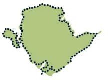
The Isle of Anglesey Coastal Path falls within a designated Area of Outstanding Natural Beauty (AONB) which covers 95% of the coast.
It passes through landscape that includes a mixture of farmland, coastal heath, dunes, salt- marsh, foreshore, cliffs and a few small pockets of woodland. This includes a National Nature Reserve (NNR).
Factfile

- Length: 125 miles / 200km
- Total height gain: 4,174m / 13,695ft
- Official start point: St Cybi’s Church, Holyhead (grid ref. SH247 826)
- Average no. of days to complete: 12
- Towns/villages directly on the path: 20
- Possible to complete all sections using public transport: Yes
Famous associations
Oliver Cromwell stayed at the George and Dragon in Beaumaris in 1643. The Morris Brothers of Pentre-Eiriannell, Dulas in 1700s. Charles Dickens wrote a diary of events about the wrecking of the Royal Charter in Moelfre, 1859. Charles Tunnicliffe lived and illustrated wildlife at Malltraeth (1950-1979). Kyffin Williams (artist) lived on the Menai Strait. The famous village of Llanfairpwllgwyngyllgogerychwyrndrobwllllantysiliogogogoch.
Friends of the Anglesey Coastal Path
Anyone who has completed the full 125 miles of the Coastal Path can now be rewarded with a special badge and a certificate recognising this achievement. To claim your badge please fill in the online form on the Friends of the Anglesey Coastal Path website.
- Getting to the coastal path
- Getting to sections of the coastal path
- Getting to the official start point
- Route descriptions and maps
- Accessibility of the coastal path
- Friends of the Isle of Anglesey Coastal Path
Section 10: Aberffraw to Four Mile Bridge
This section of the path highlights what the island is probably best known for - its sandy beaches.

Distance: 22km / 13.75miles
Height Ascended: 280 metres / 919 feet
Start: Aberffraw
(Grid Reference SH355689) Finish: Four Mile Bridge (Grid Reference SH280783)
The path follows low rocky cliffs as far as the burial chamber of Barclodiad y Gawres at Cable Bay (Porth Trecastell).
From here huge expanses of sandy beach backed by dunes stretch all the way to the Inland Sea, where you’ll join low lying farmland to Four Mile Bridge.
Downloads
Section 10: Aberffraw to Four Mile Bridge - route description
PDF (62.35 kb)
Section 10: Aberffraw to Four Mile Bridge - map
PDF (0.7 mb)
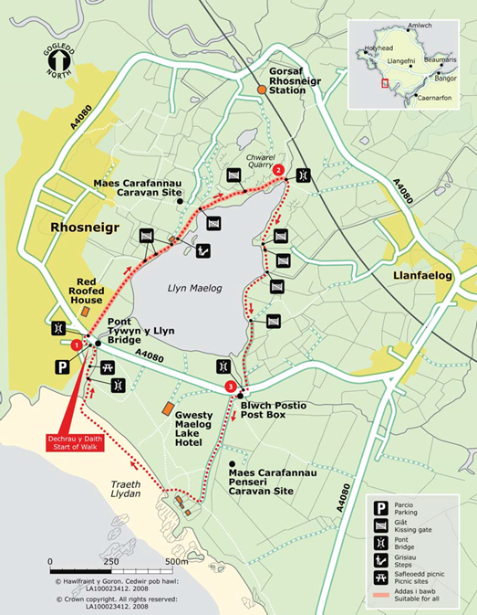
Circular walks – Rhosneigr (SH321727)
Please see the map below
1. Tywyn y Llyn Bridge – Footbridge over stream at the furthest point of the lake
Off road parking area to the left immediately past the road bridge on the A4080 when approaching Rhosneigr in a Westerly direction passing Maelog Lake Hotel on your left. The first part of the walk will be a circuit of Llyn Maelog on well defined footpaths. Start your walk at the footpath sign and boardwalk on the roadway from Rhosneigr.
Cross the footbridge and follow the boardwalk path between the metal fence and the reeds on your right. Continue along this path to where the boardwalk ends at the lake side and a small island where you will always see a variety of birds (bring binoculars). Follow the path toward the house with kissing gate and red brick boundary walls on your left. Climb up the steps to the next field and rocky outcrop with sign to indicate the wildlife conservation area.
The path now follows the line of the bracken through the field in the direction of the caravans and through a kissing gate with a sign showing David Bellamy Conservation Gold Award to Tŷ Hen 99 – 06. Follow the way marker on down side of the gate by bearing right along lake side (not over stile towards the caravans), walking between rock outcrops and following yellow marker posts through vegetation on to the field and through another kissing gate with way markers to the next yellow marker post and down to the lake side, passing the rocks on your right and on to the footbridge over the stream at the furthest point of the lake.
2. Footbridge over stream at the furthest point of the lake – Post Box
The path now follows the easterly side of the lake. Follow the path at the lake side to the gorse bushes on your left to reach the rock outcrops and bearing left to a kissing gate and path to a timber kissing gate. Follow the lake side to a kissing gate and on to another kissing gate. The path now follows between some small trees and clear grassed areas reaching a gate and kissing gate with way markers at a lane. Turn right at the lane passing entrances on your left to reach the T-junction on the A4080.
3. Post Box – Tywyn y Llyn Bridge
Turn right on to the A4080 over the bridge and cross the road on to the public footpath sign by the post box. Follow this tarmac surfaced lane with passing places, passing the public footpath sign to your left and Penseri Caravan Park and continuing on the lane. Turn right at the way marker just before the houses which overlook the beach. Turn left through the sand dunes on to the beach at the end of the houses and turn right to walk along Traeth Llydan towards Rhosneigr to reach the river running from Llyn Maelog to the sea.
Turn right along the river bank to cross a footbridge to the picnic area. Follow the path towards the houses and turn right at the wall to return to your starting point.

Whilst every effort has been made to ensure that all information is correct at the time of publication, no liability can be accepted for errors or omissions.
http://my.viewranger.com/route/details/NTY0OQ==
Playable Spaces Brochure (PDF) (6mb)
